
Mt. Nun Expedition
Leh, Ladakh
Rated 4.9/5.0 on TripAdvisor. 550 Reviews
572 Reviews (5.0)
Rated 5 out of 5

572 Reviews (5.0)
Rated 5 out of 5
Key Highlights
- Altitude : 7135 m
- Time : 19 Days - 18 Nights
- Region: Leh
- Best Time: May-October
Overview
Mt. Nun Expedition
The Mt. Nun Expedition is the finest one & is a must-climb to make the leap from hiking peaks to technical peaks. Mt. Nun Expedition, with an altitude of 7,135 metres, is the highest point in Ladakh's Zanskar Valley. The simple sight of it fills you with a sense of power. Its intimidating structure, disconcerting slopes, unexpected blizzards, and the odd way it holds you, sometimes softly but on other occasions, clearly not, continue to subtly convey its control. Mount Kun (7, 077 m), its shorter sibling on the Nun Kun massif, and this striking peak are separated by a 4-kilometer-long snow flat. About 250 kilometres east of Srinagar, in the Suru valley in the Kargil area, is where you'll find the massif. The Himalayas are a never-ending well from which mountaineers have drawn for decades in search of new and thrilling challenges. Mount Nun is a popular destination for mountaineers from all over the world because of its prominence among both known and unknown summits. The mountain is a beautiful sight and does its part to lend you a dream, serving as a stepping stone for some and a challenge in its own right for others.
Mt. Nun Expedition, has a demanding climb that calls for careful navigation of treacherous terrain in subzero temperatures while being bullied by ferocious winds from every angle. The first-ever expedition to the majestic Mount Nun was done in 1953 by Pierre Vittoz and pioneering female mountaineer Claude Kogan. The mountain's crevasse-riddled surface, unnerving habit of changing face every hour and thus changing routes, elaborate glacial formations, high gradient ice walls, technical patches, knife-edge ridges, constantly changing weather, high altitude, and strong winds all combine to make it a much tougher peak to climb than some other 7,000M peaks. Anyone without real grit and a team player's heart won't do well on the mountain. This is an adventure for seasoned mountaineers only due to the difficult nature of the climb, which requires familiarity with specialised mountaineering gear and the ability to adapt to extreme conditions. You must be a certified mountaineer or have extensive experience climbing mountains at high altitudes and in harsh climates, including having reached the top of at least one peak higher than 6,500 metres.
Cost Per Person
Key Highlights
- Altitude : 7135 m
- Time : 19 Days - 18 Nights
- Region: Leh
- Best Time: May-October
Complete
Itinerary of Expedition
The walk begins at the city of Leh, a gateway to the province of Ladakh, which is home to some of the area's highest peaks. As a result of its popularity, it is easily accessible to tourists. The first day of the climb is set aside for everyone to travel to Leh and check into their lodgings. Climbers will require some acclimation time in the mountain air since they will be coming from sea level. Overnight stay in a hotel in Leh.
Relax and adjust to the higher altitude on day two. This will give your body some time to adjust to its new surroundings and lower the risk of developing any negative health effects. You may take in the sights and sounds of this mountain metropolis by visiting the local market, museums, and other points of interest. If you want to get used to the city, a stroll here and there is a wonderful idea. You may also utilise this time to double-check everything on your excursion checklist and pick up any last-minute necessities. The best place to stock up on hiking gear is at Leh's markets. While the body adjusts to the altitude, we will have our introduction with the Expedition leader and then have a debriefing session to discuss the next days' events and activities, including the itinerary, what to anticipate, and some of the most fundamental rules for being respectful of the mountains and the environment. Overnight stay in a hotel in Leh.
This day is reserved for rest and preparation for the impending excursion. It will also give you time to prepare your baggage, allowing you to leave unnecessary items behind. It's crucial to know this since expeditions need you to do nothing except carry your own weight. As you climb higher in elevation, the physical exertion required to carry your backpack becomes more apparent. Make sure you've got everything you need, and pack your bags with care. Leaving this point, you will be far from any stores, so make sure you have everything you need before you leave Leh.
An important event is happening today. When you start driving directly towards Mount Nun, it marks the commencement of the true excursion. In addition to the guides, you'll get to know the Sherpas and the rest of the support crew. Plan on departing sometime after breakfast. The trip should take about 7 hours in the car. You probably know your way about Ladakh by now. Seven hours of driving over barren countryside, paved roads, and scented air might seem like a little trip next door. We will cross some local sights enroute to Kargil like Magnetic hill, Patthar Sahib, Indus and Zanskar Sangam and the sacred Lamayuru monastery. After reaching Kargil, we will check into our Homestay/Guest House.
Tangol, a tiny settlement on the banks of the Suru River, is the starting point for the journey up Mount Nun from Kargil. There is no hurry in anyone's step this morning since there is such a little distance to go. The trip takes little under two hours by car, but it may do wonders for your psyche during that time. As soon as you leave Kargil, you will no longer have access to any cellular networks, allowing you to focus entirely on the scenery outside your vehicle window. It's a place of winding roads, verdant towns, people lugging bundles of firewood on their backs, stark brown mountains, and a unique aroma. You have a bird's-eye perspective of mountain life on the lower slopes as you drive up the mountain, heading towards a greater height. When you see people farming and cultivating little kitchen gardens behind each stone-built home, you get an idea of how self-sufficient the mountain community really is. High-altitude life brings a sense of modesty, and the humbling sight of people bending over sickles to cultivate their land is a reflection of this. There is a sense of modesty in every facet of mountain culture, from the low doors that need a stoop to enter to the high ceilings that make it necessary to duck to avoid hitting your head. Is it a secret, then, what you, as a climber, are supposed to bring to this mountain? After half an hour of driving, the valley widens and the river seems to expand unexpectedly. The mountains become softer and greener, and fresh water trickles down from all sides to join the river. In about fifteen minutes, you will begin to see snowy peaks, a pleasant break from the landscape's muted palette of earth tones during the last four days. You seem to be heading right towards those snowy peaks that were just behind you a moment ago. A little distance into your trip, the paved roads will give way to kachcha paths, and the brown panorama of rocky mountains will come into view. With that, the greens gracefully exited the stage. To your right, left, and centre are what seem to be large boulders that have been tetris-ed into each other, a fitting greeting. The clean grey of the roadways with the bright yellow line stretching out as far as the eye can see complements the pristine rows of apricot trees, which provide beauty and colour to the environment as a whole. The mud-brown homes with wooden windows painted green are another indication of a peaceful lifestyle, as they match the two main colours of the mountains that are home to this way of life. Riding beside the muddy and powerful Suru river, you'll see whole villages perched on rocky outcrops in the heart of the valley, which begs the question: do all villages secretly aspire to grow into cities? With the elevation we've gained today, we'll do a little acclimatization hike tonight as well.
Day one of the real expedition has arrived. Ahead of you is a long, gradual climb to the mountaintops. Because we anticipate a full day, we plan to depart soon after finishing breakfast. There is a 900-meter elevation rise, and carrying a heavy pack doesn't make it any easier. In the first step, you'll make your way to the other bank of the river through a solid bridge that overlooks a deep valley and the river below. Follow this road until you reach the final inhabited settlement before leaving human habitation behind forever. The path to basecamp passes through quaint farming communities where inhabitants may be seen racing up and down the verdant hills as if they were on an Olympic track and field. Cattle dotted around the countryside, you leave the geometric greens behind at the mountain's foothills and join the world of browns on small shepherd trails: rocks, stones, and mud; exceedingly dry yet rich in flowers of all hues coming out in tufts from the land's crevices. The mountains here are odd, rocky, and pointy; they are utterly brown and dry above a certain elevation, yet they transition to beautiful green pastures below. Many shepherd pathways crisscross the area, leading you over boulder fields and scree to reach the dry greens that have been tuft-divided into mounds. You start the ascent, and three hours later you're at the summit. Both the terrain and the atmosphere are entirely different on the opposite side. The valley you reach at the bottom of the steep descent from the mountain is considerably chillier and more rustic than the one you just left. You can reach the base of the waterfalls by travelling through many kilometres of moraine and glaciers. The last portion of the ascent is very steep (almost 60 degrees) and hazardous due to the presence of loose boulders and scree. At the top of the waterfall is where we'll find the camp waiting for us. In order to reach the safety of your tents, which will serve as your dwellings for the next several days, you will need to brave the cold and traverse torrents of water from the waterfall.
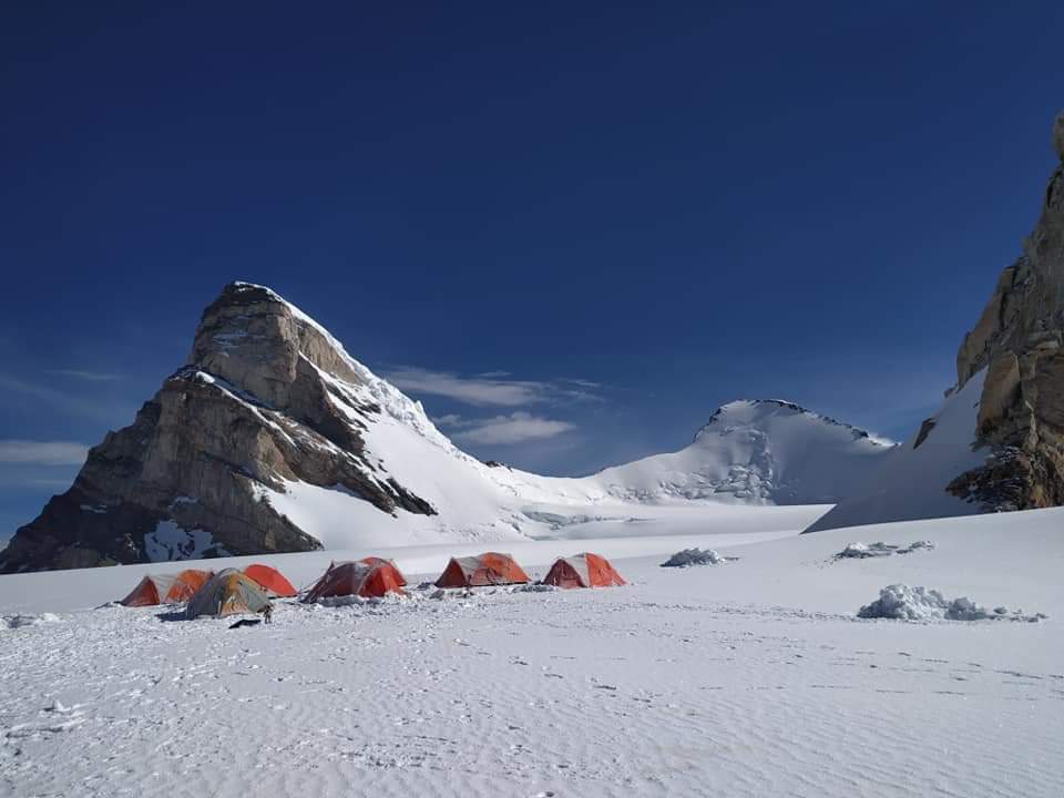
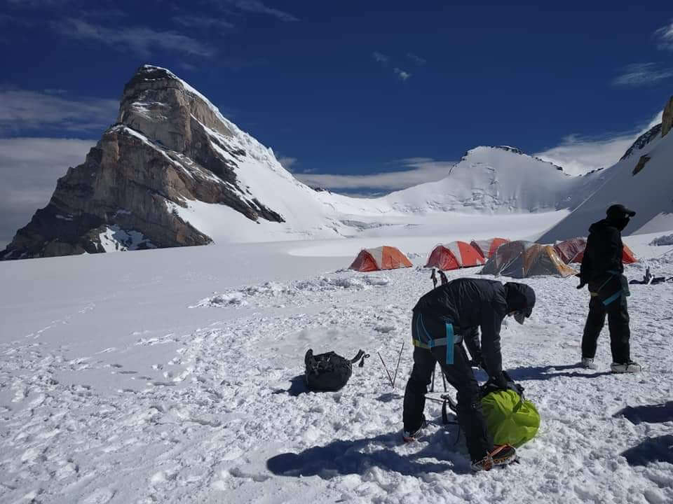
A pooja is performed each morning. As with the base camp of every mountain, Mt. Nun's is a riot of colour thanks to the prayer flags and little stone buildings built to honour the mountain gods and express gratitude for the privilege of being there. The members of the team conclude their ritual of seeking the mountain's blessings for the team's safety and success with a toast of brandy and some sweets. You'll feel more at home in the mountains and less like an intruder thanks to this technique for bonding with the massif. While in base camp, you can do a lot. Everything from setting up the camp and distributing equipment to technical instruction and practise on the snowy slopes near basecamp. But before that, you have the whole day to relax and adjust to the higher altitude and cooler temperatures of base camp, which is located at 4600 metres above sea level (or around 800 metres higher than Tangol).
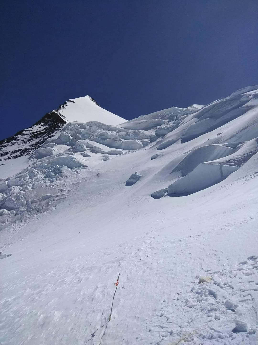
Once you begin climbing, the weather at high altitudes is completely out of your control. As circumstances change, so do the strategies used. It might be difficult to provide rigid day-by-day timetables, like we do for treks. The plan is rather vague, but it does involve the normal acclimatisation procedure of rotating between camps at high altitudes. The three camps on Mt. Nun are located 5,550 metres (1,890 feet), 6,100 metres (20,910 feet), and 6,400 metres (8,100 feet) above sea level.
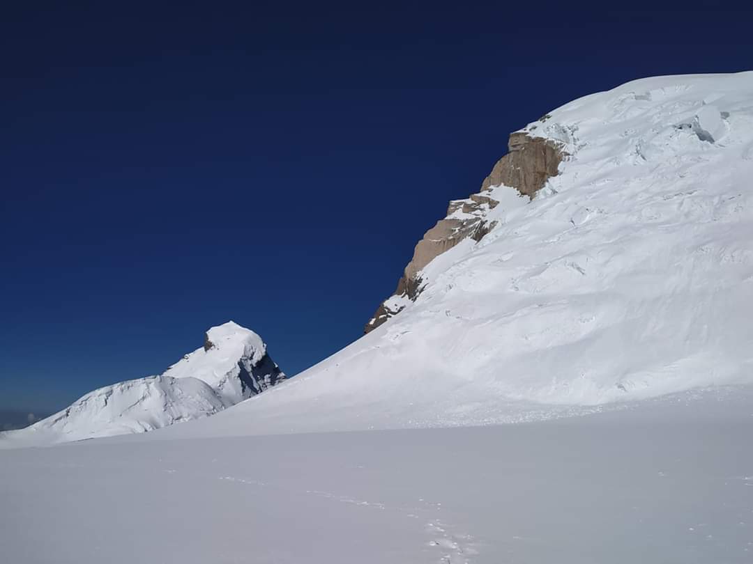
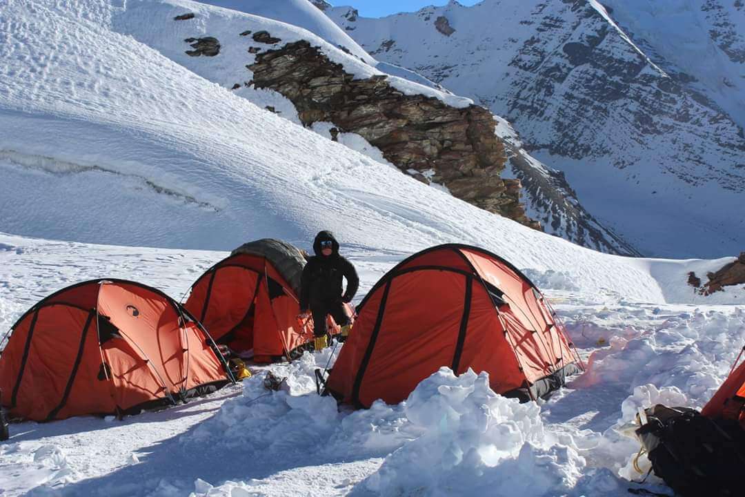
Camp 1 (5,500M) is located a 900M vertical ascent above Base Camp at an altitude of 5500M. After crossing the river and making it to the other side of the campgrounds, the first part of the path consists of a two-hour ascent up a rocky hill. There are a lot of rocks and pebbles in this section, but the route is quite well-laid out, so it's not too bad of an uphill slog. It takes around two hours to reach the top of the mountain crest and then down the other side, and the whole way there you'll have to navigate over and around enormous rocks. This notorious juncture is a large rock with a little gap at the base, making it ideal for sheltering all of our gear from the wet weather and the ferocious winds. Think of this as the pre-climb dressing room; here is where you'll be ready to tackle the mountain.
The 300 metres of 75-degree-steep ice wall between Base Camp and Camp 1 is the most challenging part of the journey. The ice becomes much more precarious after the first wall, and it must be negotiated twice. The slopes and snow become more manageable as we break through the ice wall and its extension. After making a right turn, crossing a few crevasses, and arriving at an angle of about 30 degrees, the slope becomes more manageable. The portion with the fixed ropes has come to an end, and the region with the concealed crevasses has begun. Camp 1 is situated smack dab in the centre of a snowfield that is four kilometres across. After a time, traversing the vast, level plain seems like wandering into a black void. Once you leave Base Camp, you should only have to hike for around 5-6 hours to get to your tents.
Camp 2 is located at an elevation of 6,100 metres, and the route between the two camps is a continuous rise with a gradient of 60 to 70 degrees. Climbers will spend an average of 9 hours making the ascent's final 600 metres in altitude from Camp 1. Depending on the snow's consistency, you'll be on the front point for most of the ascent. However, even with crampons, traversing the enormous boulder fields remains the most challenging aspect of the ascent.
Despite these drawbacks, Camp 2 is still quite interesting. There is little question that the high-altitude campsites on Mt. Nun are among the most stunning and exciting in the world. However, Camp 2 stands out from the other two. A blend of the seriousness of a 007 film and the levity of a Black Jack flick. Tents at Camp 2 are suspended dangerously on the sloping, narrow ridge of a towering pinnacle. You can't even go to the bathroom without first tying yourself to the rope since there's an 800 metre drop on the opposite side of an insurmountable hill. Anyone who ventures to glance upward, however, can attest to the fact that the campground has some of the most breathtaking sunrises and sunsets they have ever seen. The orange light peeking through the clouds onto the otherwise white countryside is nothing short of miraculous. From Camp 2, the sun casts a divine halo about Mt. Nun, making it much more alluring.
The scenery in Camp 2 is so breathtaking that the experience may be more thrilling than reaching the top. Sitting at that elevation with a clear view of the snowfield below makes for an incredible cloud display. Seeing the clouds cast their shadows over the vast snow field is a display worth seeing up close.
Camp 3 (6,400 m): The Summit Camp, located at an elevation of 6400 m, is a 300 m ascent from Camp 2. After making it up the intimidating hills to Camp 2, this next bit shouldn't seem too difficult. The trail consists mostly of snow dunes, with an average gradient of less than 40 degrees, after the first steep drop from the campground. Camp 3, like Camp 1, is located in the midst of a snowfield. The distance from Camp 2 to Camp 3 is around 6 hours.
Like on any other peak, the ice is most stable at night, making it imperative to make as much progress as possible throughout the night on the 7,135-meter summit push. Between the hours of 11 and 12, you begin your ascent. With any luck, the stresses of the preceding few days, both emotional and physical, will fade into the night as you settle in for the ascent and prepare yourself for success. From Summit camp, you may approach the west ridge by travelling on 40-60 degree ice, which then levels down to 40-50 degree gradients. Crampons provide an extra degree of difficulty to the last stretch, which is marked by big stones. After hours of climbing, it's tough to muster the strength to lift yourself over the huge boulders and bear your own weight. But after you get up beyond those stones, you're just about 50 metres away from the peak. It would likely take you 14-16 hours to make the return journey from Summit Camp.
We have a hard day ahead of us as we go from Camp 3 to Base Camp. In the morning, after breakfast, you should be ready for some really steep descents. Keep as sharp an eye on your surroundings as you did on the ascent; low energy levels might cause you to lose concentration. It might take you anything from 8 hours to 10 hours to finish this experience.
After getting some rest at Base Camp, you should descend to Tangol and then continue on to Leh. It's a short, simple distance that can be covered in around 4 hours. Soon after, we board our buses and go south to Leh. You won't get into Leh until the wee hours of the morning.
There will be a party here since your journey for Mt. Nun Expedition has come to a conclusion. The journey can't come to a close without celebrating at the peak. The essay below may serve as a starting point for your planning purposes if you want to spend a few more days in Ladakh exploring its attractions. To see what I mean, visit this link: High-altitude circumstances, including the weather, are notoriously difficult to anticipate. As a result, we advise you to schedule your return home with a few days' worth of buffer time once the adventure ends.
Enquiry For Group Bookings
Guidelines
➽ Preparation for Expedition
As you know every mountainous excursion demands a precise planning, a planning with adequate pliability of observing and tackling situations, held all as by overcoming mind body and soul throughout the incredible Himalayan journey.
So here are some aspects regarding Mt. Nun Expedition preparation:
⦿ Physically – A trek demands physical endurance, to prepare for each trek you should work out a month before joining a program. Build up the adequate strength in your legs by running and exercising every day to boost up your endurance. Stop smoking and boost your lungs doing breathing exercises at routine basis two times a day, which will help acclimatize the conditions while being resilient on the trek. Take active part in outdoor games, Yoga and any other cardiac exercises.
⦿ Mentally – Mental preparation is key, equally as important as physical training requisite for a trek. Before joining any trek take pleasure in your daily routines, eat well, take rest properly and relax. Do not stress your mind by unnecessary predictions about the trek. Be with your best friends to get motivated and relax your mind. Because pre trek assumptions are not worthy because once you join the trek and meet with rest of the pack will bring encouragement and excitement. The mental preparedness will build through the entire trek conditions. And the physical drawbacks will affect the mind. So pay close attention to various parts of the body and consciously let them loosen up as you trek. When you trek try to relax your body, especially your hips. If you’re on a winding downhill trail or on a panicking slant, think of each step as part of a simple dance and enjoy the natural rhythms that the terrain and your body can find together cautiously. Experiment with different ways of walking as a way of finding enjoyment beyond the goal of reaching a destination. The main key to stay mentally fit is to enjoy the route and not to pressurize the mind.
Guidelines
➽ Things to Carry
- Good Trekking Boots: You need sturdy trekking boots with supportive high ankles. Don't bring your running shoes. U can carry extra floaters/flip flops also.
- Wear warm clothing, such three-layer coats, fleece upper, hollow fill or down-filled jackets. Carry full-sleeved T-shirt. Carry cotton hiking trek pants and warm pant for your lower body. Never bring shorts or jeans on a hike.
- Take top and bottom thermals with you.
- Quick dry towel with light weight and Personal toiletries. Suns cream lotion, sanitizer, tooth brush ad toothpaste, lip balm and antibacterial powder.
- Socks: Bring two pairs of regular socks and two pair of wool socks for wearing at night.
- A head torch is required.
- Sunglasses/ Goggle: UV-protected sunglasses are necessary to protect against sunlight and Snow Mountain.
- There should also be a woolen cap / balaclava, cap, neck gaiter cum face mask and warm fleece and waterproof summit gloves since it will be chilly. Keep waterproof gloves on hand since they become wet in the snow.
- Everyone taking part in the activity should have their own lunchbox, spoon, mug and water bottle/ hydration pack of 2 ltr.
- Raincoats/ponchos: Since snowfall and rain are frequent at high elevations, it is important to have one on hand so as to avoid getting wet.
- Trekking bag of 75 ltr with rain cover.
- Walking stick.
- Personal first aid box. Emergency ration, energy bars, dry fruit, electoral/Ors
- Personal technical gears list of mountaineering (on rent basis available)
- Climbing boot, Crampon, Sleeping bag (optional), Ice axe, seat harness, Rope and tape sling, helmet, Summit gloves, Gaiters, Carabineers 2 no (screw), figure of eight/descendor, Zumar (Ascendor),
- Required Documents:
a) Registration Form
b) Medical Certificate (signed by a licensed MBBS physician)
c) NOC form (completed by the trekker)
d) 2 passport-size photos
e) ID Proof photo (not PAN)
f) Basic Mountaineering Course certificate.
g) Insurance upto 5 lac..
Guidelines
➽ How to Reach
Travel Time by Car:-
You will travel from Delhi to your final destination of Leh through the cities of Karnal, Mandi, Manali, Jispa (via Rohtang Pass), Sarchu, and Tanglang La.
Location: 1011 kilometres away (approx.)
Closest Airport:-
An aeroplane is the most convenient way to travel. The focal point is the city of Delhi. You may get a flight to Leh once a day from Delhi. Travelers between New Delhi and Leh may choose from three airlines: Jet Airways, Air India, and Go Air. Due to a subsequent price increase, advanced reservations are strongly recommended. With so many snow-capped mountains, road travel is almost impossible. Flying is so much more popular.
➽ Trip Cost Includes
- Mountaineering (Instructor/guide) services provided by a highly trained, professional, and qualified Himalayan Adventure Trips staff.
- Certified local guide with extensive familiarity of the area.
- Climbing provides only vegetarian food (breakfast, lunch, and dinner).
- Staff include chefs, cooks, and helpers.
- High Altitude Force, Low Altitude Force, Porters, Mules for Common Equipment (Rations, Tents, Utensils, Central Climbing Equipment, etc.)
- Tents (to be shared), sleeping bags, air mattresses, and air pads are included. Inner
- We offer twin-share accommodations in dome, alpine, and high-altitude tents on all of our treks and expeditions. All necessary camping equipment, including air mattresses, a shelter for cooking and eating, a table and chairs, a stool, and more, would be supplied.
- Someone who can carry heavy items, set up high camps, repair ropes, etc. at high altitudes.
- Assistance from Guide All the Way to the Top
- High-altitude butane gas cooker
- The only meal offered at the hotel will be breakfast. All meals while on the walk will be supplied for you. Indian, Chinese, and Continental cuisines, all freshly cooked, will be on the menu.
- Tin-packaged food is what we'll eat at high altitude.
- A standard first aid kit with oxygen masks for the patient.
- Camping fees, wildlife fees, and forest permits.
- Taxes imposed by the state.
➽ Trip cost Excludes
- Climbers may hire individual porters to carry their gear.
- Airport transportation costs
- Expenses for carrying still/video cameras etc.
- Irregular/Personal costs, such as laundry, phone calls, and gratuities.
- Climbing equipment such as ropes, pitons, snow bars, crabs, etc.
- Your own personal mountaineering equipment and clothes, as well as any specialised foods you may need
- Inner Line Permit.
- Health coverage or the price of a rescue mission
- Expenditures of a more personal character (such as booze, soda, bottled water, mineral water, canned or bottled drinks, candy, canned or packaged dried fruits, etc.)
- Provisions/food to or from the starting point of the trek.
- Any expenses that are incurred as a result of natural disasters, human error, or other unforeseeable occurrences.
- Protect your trip with a travel insurance policy.
- Authorization, licensing, and enlistment with the IMF.
- Payment for Liaison Officer (included for foreign expedition only)
- GST of 5%.
Guidelines
➽ Special Casual Leaves
Government employee can avail the benefit of special casual leave when u join us for a trekking expedition. As per the rule of the pay commission, special casual leave can be availed for up to 30 days in a calendar years for trekking and mountaineering expeditions through a register organization. Himalayan adventure trips are a register adventure tour operator register with Indian mountaineering foundation and Himachal Pradesh tourism. Candidates have to apply for leave at least 30 days before the trek/expedition start.
Read
➽ Frequently Asked Questions
Mt. Nun is located in the Indian state of Jammu and Kashmir, specifically in the region of the Himalayas. It lies in the Zanskar range, near the town of Leh.
About 7135 meters (23,409 ft) above sea level.
The most common way to reach Mt. Nun is to fly to Leh, the capital of Ladakh, and then travel by road to the base camp of the mountain.
The best time for climbing Mt. Nun is typically during the summer months, from June to September, when the weather is relatively stable and the snow conditions are more manageable.
Climbing Mt. Nun is considered to be technically challenging, requiring advanced mountaineering skills due to steep terrain, crevasses, and unpredictable weather conditions.
Yes, prior mountaineering experience is highly recommended, preferably on peaks of similar or lesser difficulty, to ensure safety and success on Mt. Nun
Equipment required for climbing usually includes crampons, ice axes, ropes, harnesses, helmets, walking poles, & camping gear, but most of the things will be provided to you by us. You need proper clothing for extreme cold weather conditions. Many important things is already mentioned above on this page.
The main dangers include altitude sickness, crevasses, avalanches, extreme weather, and rockfall. Proper preparation, acclimatization, and caution are crucial to mitigate these risks.
The length of time taken to ascend & descend the peak usually takes 19–18 days
It is highly discouraged to attempt Mt. Nun alone due to its technical difficulty and the inherent risks associated with high-altitude mountaineering. Climbing with an experienced team and guide is strongly recommended for safety.
Permits for climbing Mt. Nun can be obtained from the Indian Mountaineering Foundation (IMF) or the local authorities in Leh. But don't worry we will help you & do this task on your behalf.
There are ATMs available in Leh, the nearest major town to Mt. Nun base camp. However, it's advisable to carry sufficient cash as facilities may be limited in remote areas.
Some other famous treks and expeditions in the Leh Range include Stok Kangri, Kang Yatse, and Mentok Kangri. Each offers its own unique challenges and breathtaking views of the Himalayas.
Testimonials
➽ Provided By The Customers
Everything about our visit to Prashar lake was better than we could have imagined. From our initial contact with Himalayan Adventure Trips, we felt their genuine interest in learning about our group's goals and expectations, and our travels with them reinforced at every turn that they not only understood our requirements but also have the acute skill and expertise to achieve them. Having already had such a wonderful experience with this firm, I will be promoting a trek to Prashar lake to all my friends who share my passion for hiking and will specifically recommend that they work with this outfit. Absolutely fantastic; I have nothing but praise for it.
Akshay Nanda
How useful was this post?
Click on a star to rate it!
Average rating 5 / 5. Vote count: 1
No votes so far! Be the first to rate this post.

 (1)")
 (1)")

