
Kang Yatse 2 Peak Trek Expedition
Ladakh
Rated 4.9/5.0 on TripAdvisor. 550 Reviews
572 Reviews (5.0)
Rated 5 out of 5

572 Reviews (5.0)
Rated 5 out of 5
Key Highlights
- Altitude : 6250 m
- Time : 12 Days - 11 Nights
- Region: Leh, Ladakh
- Best Time: May-September
- Distance: 70 Kms
- Grade: Moderate
Overview
Kang Yatse 2 Peak Trek Expedition
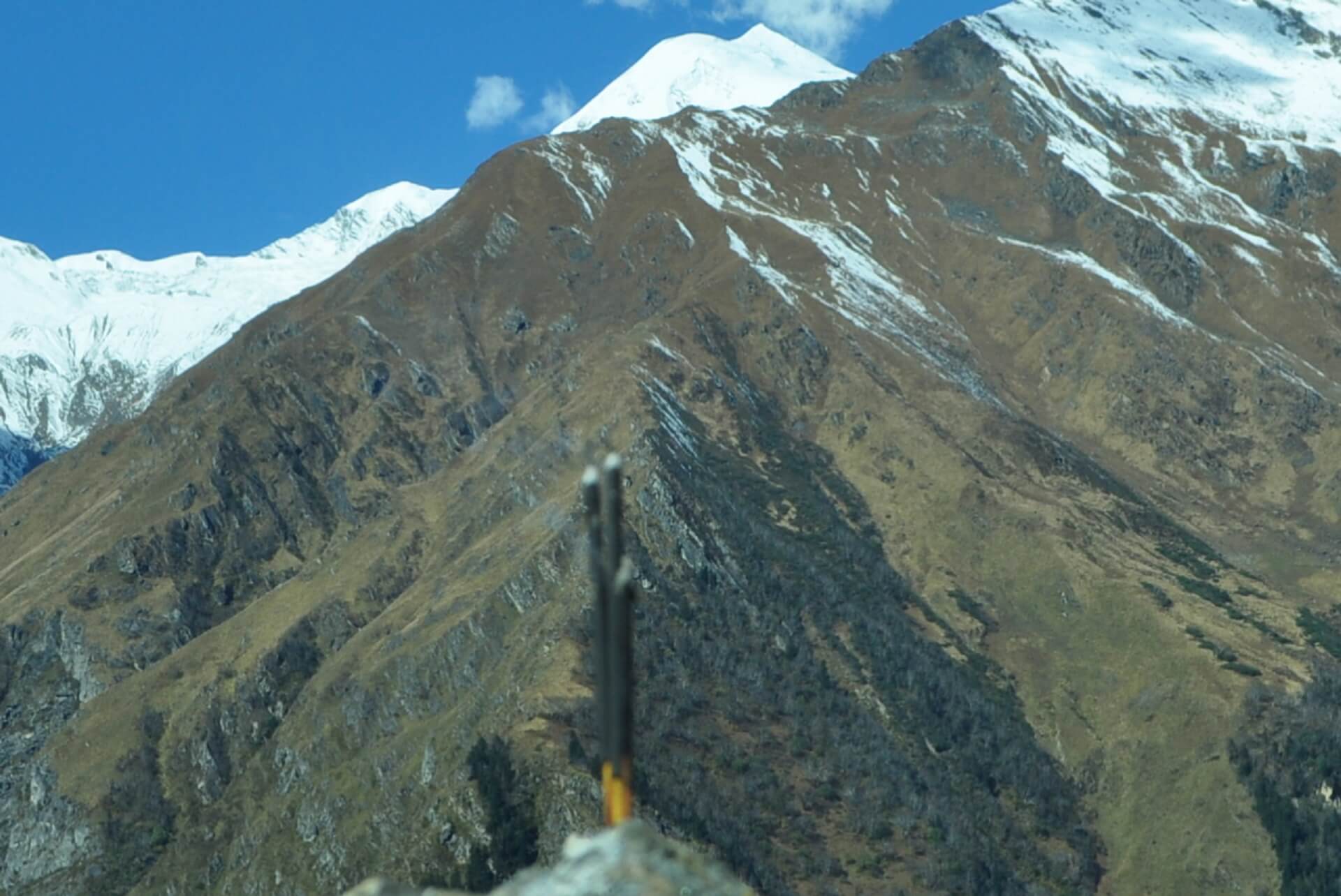
Kang Yatse 2 Peak Trek Expedition, also in Hemis National Park, is the shorter of its two relatives, Kang Yatse 1 Trek Expedition, which stands at 6,400 metres. On our sixth day of hiking, we finally get our first glimpse of Kang Yatse II, one of the highest trekking peaks in Ladakh's vast, dry landscape. We'll be making our way to its base via Markha Valley. Standing towering amongst the parched plains of scree and loose rocks, the summit is a piece of beauty.
Even before leaving the high alpine city of Leh, you will be surrounded by natural splendour. From the drive up to Skiu, where the Zanskar and Indus rivers meet, to the odd glimpse of native animals, to the agonisingly dry but breathtaking climb through Markha Valley, all the way to the foot of this coveted mountain, its 6,250M of splendour is impossible to ignore. A taste of the local culture and way of life may be gained by travelling through the few towns that dot this dry terrain. The terrain is dotted with temples, mani walls, and stupas that attest to the religious beliefs of the local population. The prayer flags provide some much-needed vibrancy into an otherwise colourless setting. They also help to calm the steadily decreasing oxygen levels as we ascend this beautiful mountain. Old monasteries, destroyed forts, and abandoned constructions abound in this mud civilization, all of which blend in with the region's unusual geological features, contributing to the area's air of mystery. Although much of the hike is spent covering distances across rough terrain, the hardest part of the expedition occurs on summit day, when we gain an elevation of 1,200 metres in a single day.
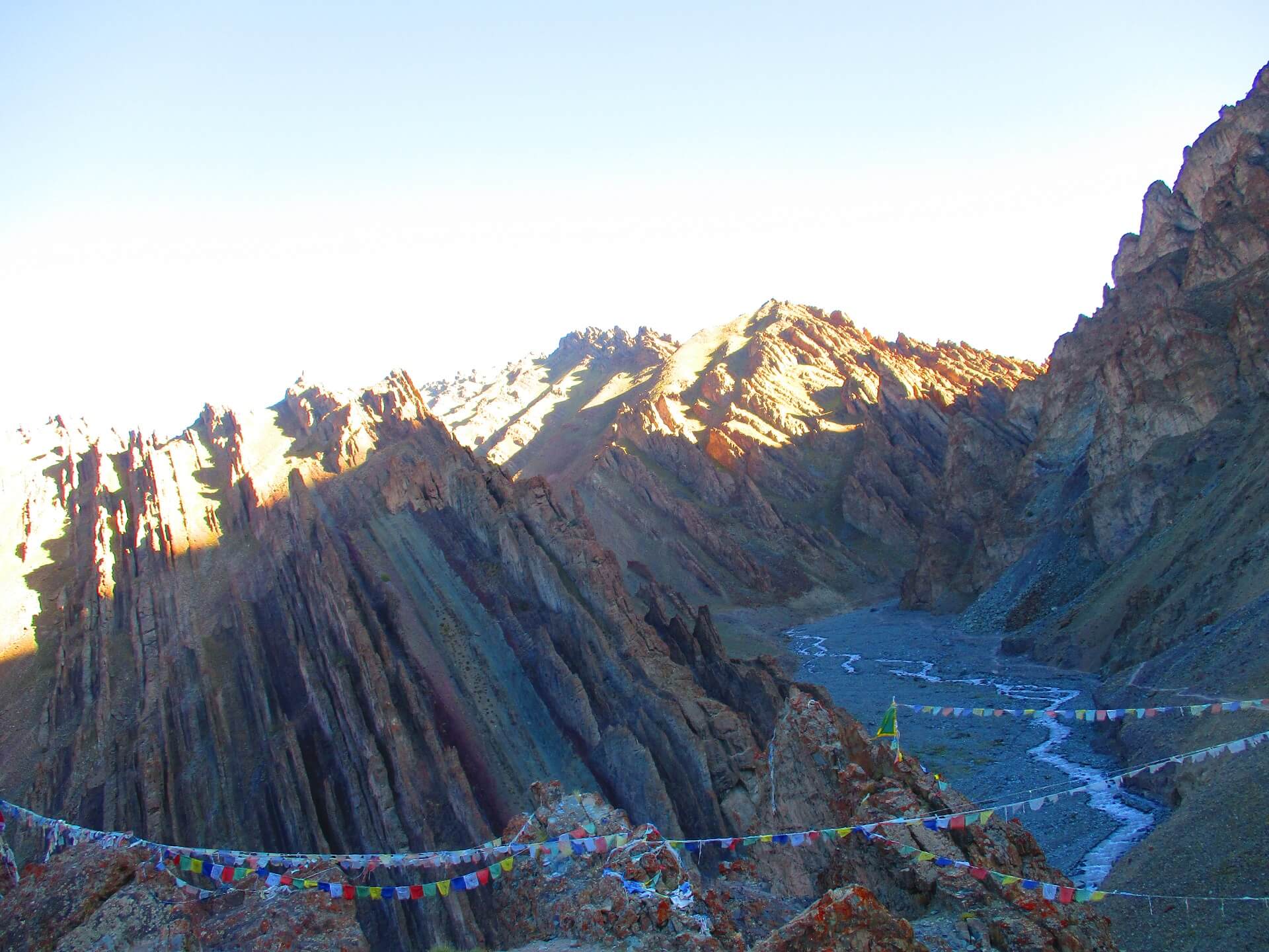
The descent of Kongmaru La, a high altitude pass at a height of 5,236 metres, is another aspect of the journey that, on its own, is enough to put it at the very top of your must-do list. There are just a few places with a high slope on the way up to the Kongmaru La pass, which offers spectacular views of Kang Yatse I, Kang Yatse II, and Dzo Jongo in between lengthy stretches of flat country abundant with pikus and marmots. The prayer flag-draped pass is where a ferocious wind meets the mountain peaks. As you make your way down from the pass, the valley will emerge and fade around every bend. The landscape is visually captivating, with rocks of every imaginable hue strewn over the landscape and gigantic cliffs rising vertically on either side of you as you make your way through geological formations filled with the oddest and most fascinating flora and wildlife you have ever seen.
Trekking peaks, like Kang Yatse, don't need special gear or expertise. However, due to the high altitude and tremendous physical exertion necessary, this hike is recommended only for seasoned mountaineers. The months of June through September provide ideal conditions for scaling this mountain.
Cost Per Person
Key Highlights
- Altitude : 6250 m
- Time : 12 Days - 11 Nights
- Region: Leh, Ladakh
- Best Time: May-September
- Distance: 70 Kms
- Grade: Moderate
Complete
Itinerary of Expedition
The journey begins at Leh, a gateway to Ladakh, where some of the world's highest mountains may be found. It's also easily accessible, making it an ideal vacation spot. See whether the article (Travel choices from near Leh) can help you figure out how to travel to the high-altitude climbing epicentre. The first day of the expedition is set aside for climbers to travel to Leh and check into their lodgings. Due to the fact that mountaineers will be arriving from sea level, acclimatisation to the thinner air at higher elevations will be necessary.
Plan on taking it easy and giving your body time to adjust to the higher altitude on day two. This is crucial because it gives your body time to adjust to its new surroundings, decreasing the likelihood of developing any negative health effects. You may go sight-seeing in the surrounding area, see some of the neighbouring attractions, or just wander the city and immerse yourself in the vibrant colours and unique culture of this mountain metropolis. It would help with acclimation to go out and about in the city a little. You may also utilise this time to double-check everything on your excursion checklist and pick up any last-minute necessities. The finest market to stock up on hiking gear is in Leh. While the body adjusts to the altitude, we have a debriefing session to discuss the next days' events, including our itinerary, what to anticipate, and some of the most fundamental rules for being respectful of the mountains and the environment.
The journey from Leh to Skiu provides an ideal preview of the next days' surroundings. We get ready and go off between 10:30 and 11:00 AM so that we can be at the campground in time to pitch our tents, create some campfires, and enjoy a hot meal while we adjust to our new surroundings. It's a really relaxing ride. Almost an hour and a half later, after driving across a flat and bleak plain beside the river Indus, we reach its confluence with the distinctively coloured Zanskar River. During our brief journey, we saw bare mountains in a wide variety of shapes, sizes, and surfaces, including perfectly stacked slabs of rock, carelessly piled pieces of rock, sheets of rock pushed tightly together, loose rocks, mud mountains, and many more. It's as if God used the whole thing as a dumping ground for the many failed clay sculptures He made. By the time we get to the campground for lunch, we will have been through some of the driest regions you have ever seen. There are a number of dispersed, little settlements here, and the surrounding fields are all a little bit greener as a result. Greenery is a sight for sore eyes because of how new and vibrant it always seems. After lunch and setting up camp, we'll take an early evening stroll to help us adjust to the altitude. A new environment calls for an acclimatisation walk, since the human body need time to adjust to its new surroundings. You should always have a water bottle with you. It won't take long for you to notice that the weather in this area is somewhat unusual, being as hot, dry, and dusty as it is. There is a high probability that your neck may feel dry due to the heat. Yet this is typical. It will take time for your body to readjust.
Upon approaching Ladakh, the first thing you will notice is the tremendous dryness; your throat may feel scratchy and your face may feel scorched by the intense, unfiltered sunlight. As far as the eye can see, the Marka valley just adds to this dry atmosphere. Think about it: you're out in the hot sun on vast, open plains, with no trees to provide shade, and the surrounding mountains seem like they may collapse at any moment. Those people aren't doing it out of the goodness of their hearts. The Markha valley journey takes you to a strange and wonderful land of dirt, heat, and unrivalled beauty. It's going to be a long day, so we need to get going as soon as possible. We have an early morning yoga practise and breakfast, then we break camp and go out to Markha Village by 8:30 AM. Wear warm layers in the mornings because of the terrain. The path is rather flat and straight today, with just a few short, gentle climbs. The sharp peaks of the rocks, the poplar trees, and the muddy route all appear to be one continuous scene as we trek for five days to reach the peaceful camp of Kang Yatse II. One of the few signs of life in an otherwise still terrain is the silvery river that winds its way down the valley floor in flowing cascades, glistening in the harsh sunlight. At the 2.5-hour mark, we reach a little wooden bridge that stretches over the fiercely running dark creek. An hour later, we'll have arrived at Sara, which is exactly halfway to our final goal. The terrain consists mostly of unpaved roads and the stony bottom of the ocean. By 4 o'clock at the earliest, we will have arrived at the campground. We've set up camp in the middle of the long green grass against a background of bare mountains, and now it's time for the acclimatisation walk. We'll spend the remainder of the day looking around and relaxing.
Even though today is shorter than yesterday, we still have a lot of distance to cover. There are vast stretches of flat country interspersed with gentle hills and valleys, and this is essentially the whole landscape. Today, like Day 4, we begin promptly at 08:30. After just an hour of hiking, we come to our first ford. The fluctuation in water levels is quite difficult to forecast. Wading through water up to your waist is an option, or you may hop, skip, and leap over the stream if the water level is low enough. Within an hour of fording the river, we've arrived at Tacha Gompa, a monastery perched on a cliff's edge, its mud-covered garb a perfect metaphor for its location on top of a muddy mountain. After a another hour, we reach a steady uphill section leading to a tavern in a nearby hamlet, where we may relax and refuel. It'll take us two hours to get to our day's camping. After just an hour of hiking, we begin to get glimpses of Lower Hunkar. It's an open area where the thick plants stop and you can see for miles as the mountains blend into one another. You'll leave the river's edge and begin to ascend a little bit higher now. The trail's lack of rough ground might make it seem boring at times, but the many opportunities to refresh your feet in the chilly water serve as a welcome reminder to pay attention. We camped out in the midst of a wheat field. In the backdrop, distant communities with widely spaced dwellings serve as a kind of outer defence for the tents. In the afternoon, we'll go on an acclimatisation stroll about Hunkar, and there's a lot to see and do there. You won't have any complaints about this stroll!
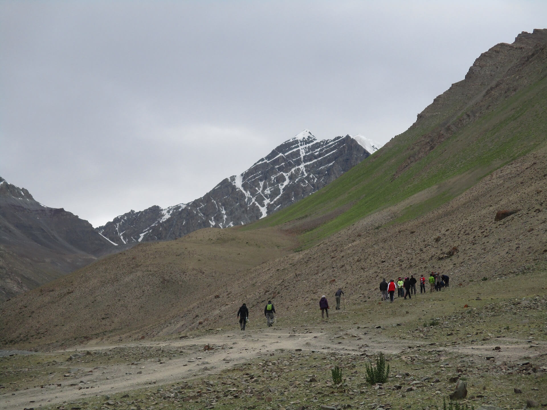
One of life's greatest pleasures is sitting in the middle of a frigid morning and watching the sunshine gently creep to you, as if tormenting you. We have a lot of area to cover and height to gain today, so we begin as early as we have in the past. By 8:30 a.m., we've finished breaking camp and are on our way out of the campground. In only 15 minutes, we'll have climbed 100 metres in elevation to reach Upper Hunkar, a little village of dwellings smack in the centre of lush green fields dotted with colourful flowers. The prayer flags that decorate every town in this valley break up the otherwise monochromatic landscape. Mani stones, sacred rocks, may be found in every community and along the paths connecting them. Adding to the unique atmosphere of the valley are stone plates and pebbles etched with Buddhist mantras. Often as a tribute to the local spirits, mani stones are arranged in mounds or scattered along highways and waterways. As a continuance of their belief that the cosmos revolves clockwise, generating circular patterns, the locals insist that these constructions be traversed from the left, a practise that is also viewed as a recurring pattern in all Buddhist practises. The fields around each town are arranged in odd geometric patterns that contribute to the overall weirdness of the landscape. We do a U-turn at Upper Hunkar, a little settlement, to get to the other side, and then go left into the valley in the direction from where you can view Kang Yatse. We keep going on the stones and rocks along the river. In an hour, we'll be leaving the riverbank and climbing a muddy mountain. The peaks in this area appear like cardboard mountains, robust yet twisted in parts in weird ways ready to shatter on one severe hit. There isn't a soul in the valley who is in a rush, save maybe that one lonely cloud up in the otherwise clear sky. Each blind bend reveals a fresh perspective, each with its own set of mysteries, and the yellow and pink flowers just contribute to the chiaroscuro effect. Within half an hour of the rise, we reach a tiny piece of downhill carrying us to a bridge to be crossed over to the other side of the river. Our stopping station is a barren campground at 4,195M where we fill water from a fresh water spring and lie down for a little among the abandoned stone constructions. At this point, we no longer need to worry about the water. It's going to be a long, steady climb up to Twin Lake from here. It will take us three hours to reach there from our resting location. Best views of both Kang Yatse peaks, I and II, may be had near Twin Lake. In the midst of the placid water, a Buddhist statue stands as a focal point for the lake, which is decorated with prayer flags. Next to the lake is a tiny enclosure that serves as a sacred gathering spot. From here on out, the landscape is largely level with a few humps until you reach the campground. Keep your eyes peeled for marmots, which can go at the speed of light, and the adorable pika, who are both very active and little. Nimaling, our day's campsite at 4,535 metres, would have been within reach if we had continued on this fairly level area with numerous rodents, horses, donkeys, and herds of yaks for another two hours. The sunset from this campground is not something you want to miss. During the evening, we take a stroll to help us adjust to the altitude.
After the lengthy days traversing Markha Valley, the path to reach the base camp may not appear very tough. In the early hours of the day, we leave the safety of Nimaling to begin the five-hour hike to basecamp, which is at an elevation of 5,100 metres and represents a net gain of around 600 metres in height for the day. From the open ground of Nimaling, the route for the base camp begins as an upward climb over loose rocks and scree, until we come to the top of the ridge — this is also when you get a full glimpse of the mountain in all its majesty. The route softly slopes downwards from here on, until we go over the river to the other side which is the foot of the mountain and also our camp for the day. The remainder of the day is spent adjusting to the thinner air at a higher altitude. As is customary, plan to arrive in time for a hot meal and go on a short acclimatisation walk in the wee hours of the evening.
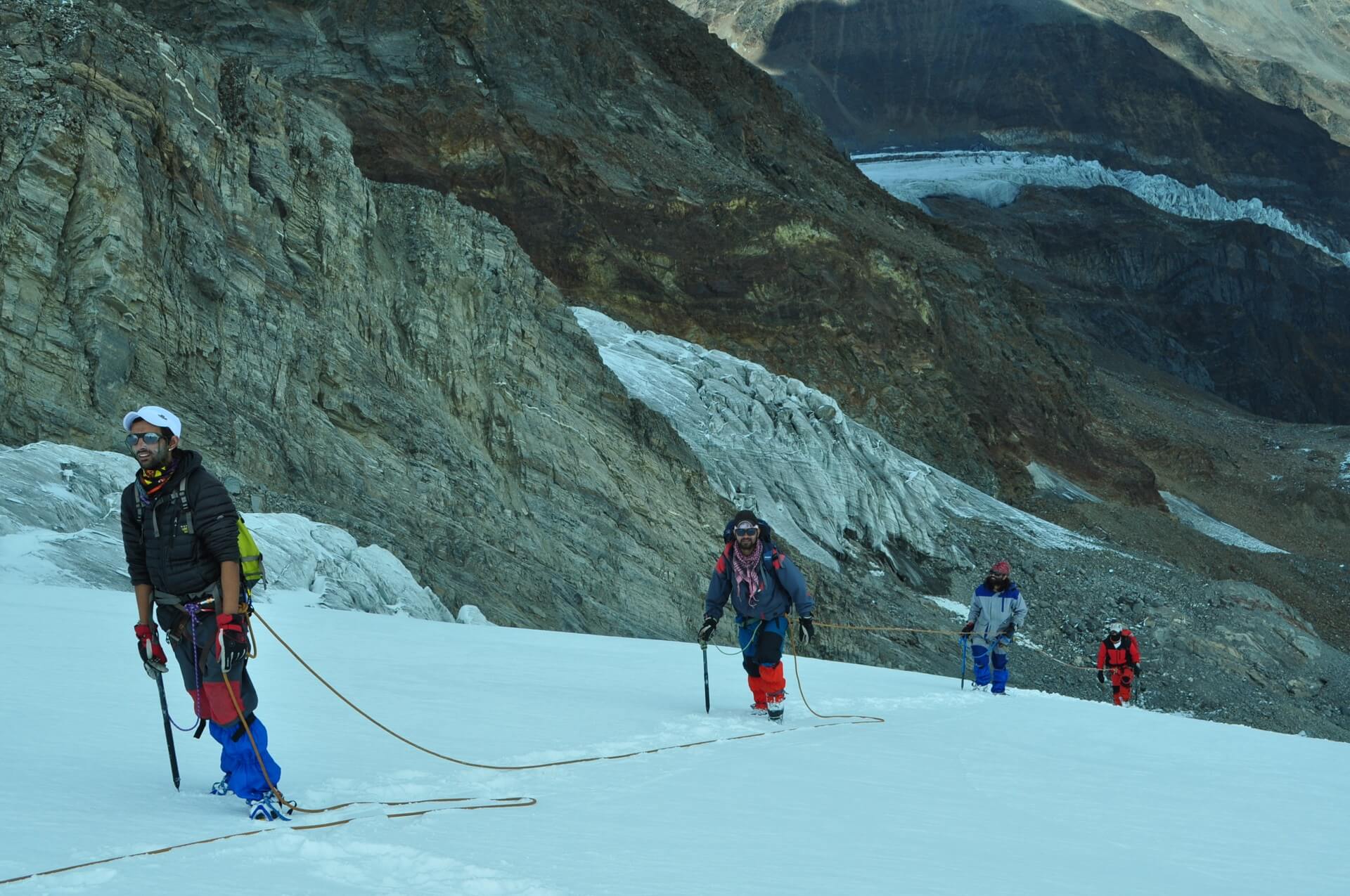
Today is scheduled for acclimation to the altitude as we gained quite a bit of height the previous day and have also entered a considerably different area. We utilise this time to distribute equipment and gears essential for the climb and also to practise fundamental skills we will use for our summit attempt tonight. After a leisurely morning spent distributing gear and eating a late breakfast, we go to the neighbouring hill for some practise runs and to get used to our snow boots, ice axes, and crampons. We'll be instructed on the ins and outs of roping up, as well as the appropriate calls to use, while travelling through snowy ground. The use of an ice axe, both for climbing efficiency and protection in the crevasses present in this area, is another skill we acquire. We call it a day early so that everyone may get plenty of rest before we start our ascent later on.
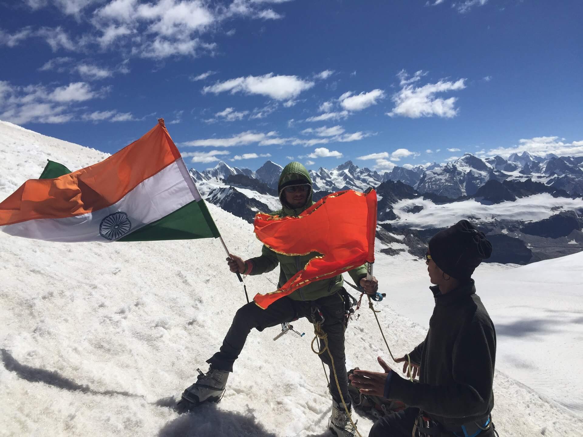
NOW is the time! We depart for our summit push between 11 PM and 12 AM. It will be a long day and a chilly night. We leave Base Camp and make our way up the hill to the right until we reach the crest of the mountain. Although the track is clearly defined, the terrain changes here to loose scree and moraine which is treacherous and has to be navigated with care. We proceed ascending the ridge till reaching the ablation zone of the glacier from the north face of Kang Yatse II. After a short 100m ascent up the moraine ridge, we rope up and enter the glacier. We will ascend the north face toward the northwest ridge while slowly going higher. After circling to the northwest ridge, we continue straight up and across a rocky protrusion, eventually reaching the peak by staying on the ridge. We should make up to the peak between 7:30 and 8:00 in the morning, spend some time taking in the breathtaking vista, and then begin our descent. We need to make it back to base camp in time for a hot lunch and before the snow becomes unstable.
A backup summit attempt is planned for Day 10 in case of inclement weather or other challenges. In the very unlikely event that anything completely out of the ordinary happens just before the initial summit push, this plan B will be used.
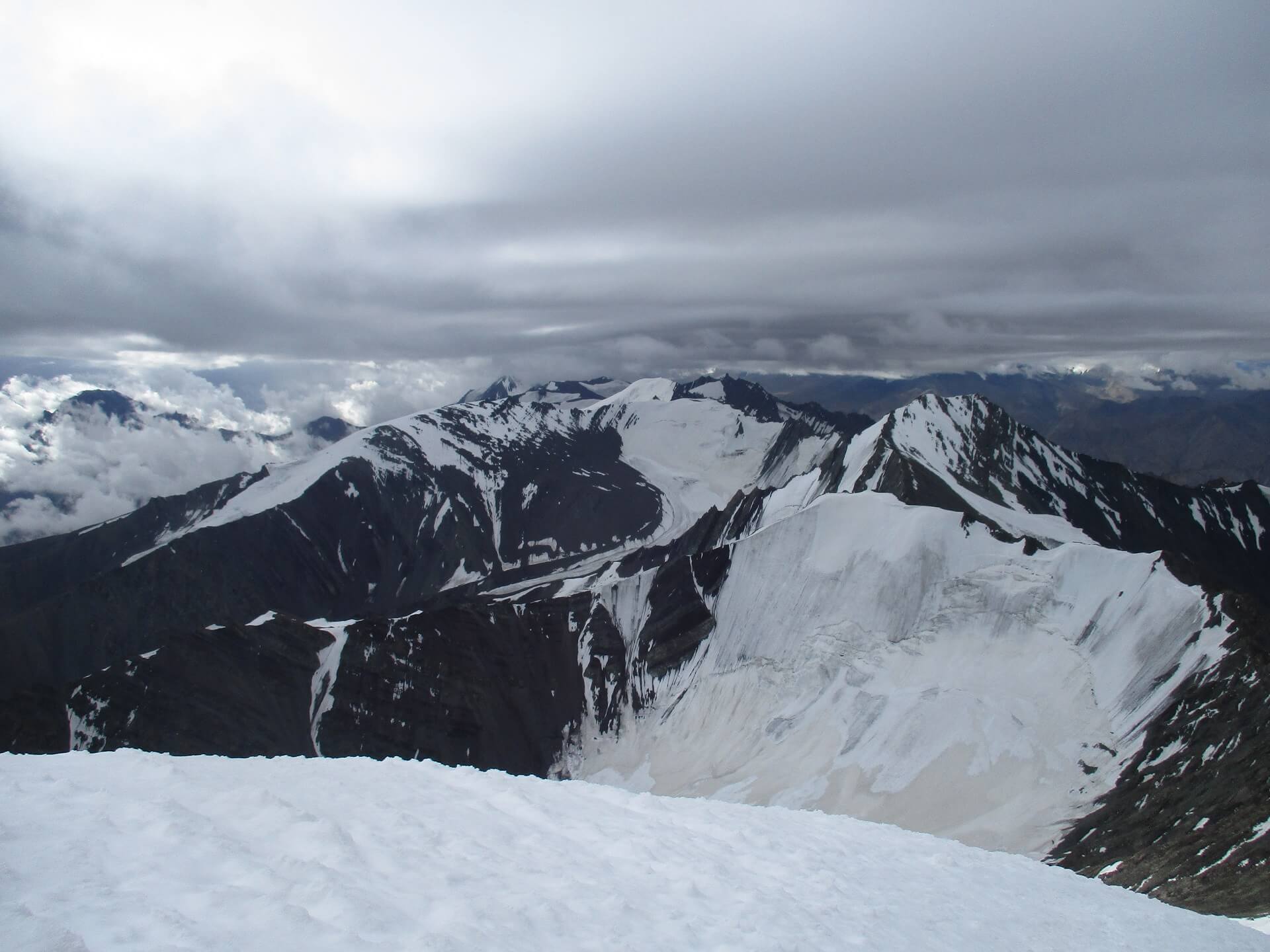
Each day of our walk, including today, is lengthy, but that's just the nature of Kang Yatse. Today, instead of heading straight down to Leh, we'll be passing through the 5,236-meter-high Kongmaru La Pass. Since we have a long way to go before we reach the road head from where we will be driven to Leh, we get an early start. We break camp and travel down the mountain in the morning. Our descent path to Nimaling is the same as our ascent route. We begin our ascent of the mountain from the other side, from Nimaling. As the clouds lash out in every direction, the sun's radiance takes on a variety of pinks and reds, from pale to vibrant. When the sun hits the snow on the summits, it reflects its light like a fire, heightening the landscape's dramatic effect. During the morning at Nimaling, the river rushes from the meadows towards the mountains as a plethora of animals revel in the new day. There are no particularly perilous areas on this day, but the distance and the parched landscape make the journey arduous nevertheless. There are just a few places with a significant inclination on the way up to Kongmaru La pass, and the rest of the way is flat, but home to many pikus and marmots. After 3.5 hours of hiking, we reach the foot of the pass, from whence we must ascend a hard inclination for another half an hour to reach the summit of the mountain. The pass offers stunning panoramas of Kang Yatse I and II, as well as Dzo Jongo. The prayer flag-draped pass is a dangerous place to be, as the air there can be quite gusty. The locals here use this pass frequently to make phone calls, as it is connected to a fast and reliable data and telecommunications network (though you lose a few steps on either side of the pass). From Nimaling, this location is about 2 kilometres away. After reaching the pass, the only option is to descend via a treacherous, narrow path through gorges and across streams, with the valley appearing and disappearing at every bend. The geological formations, which include massive walls of rocks standing vertically on either side of you and the gush of water filling up these narrow passageways, are fascinating, as are the bizarre and fascinating flora and fauna that can be found there. From where we started in Chokdo, we drove for three hours to Leh, going up, down, and in every other direction imaginable. A late-evening arrival in Leh is to be anticipated.
This is the last stop on the journey, and it is cause for celebration. If we don't celebrate our accomplishment at the peak, how are we supposed to wrap up our adventure? Read on if you want some suggestions on where to go if you decide to extend your trip to Ladakh and see its many attractions. Traveling to Leh Ladakh? Here Are Some Attractions. High-altitude circumstances, including the weather, are notoriously difficult to anticipate. We advise leaving a few days between the conclusion of the excursion and your scheduled return home.
Enquiry For Group Bookings
Guidelines
➽ Preparation for Expedition
As you well know, the great Himalayan expedition is one that requires careful preparation, a strategy that allows for enough flexibility to adapt to whatever challenges may arise.
Therefore, here are some things to consider before setting out on your Kang Yatse 2 Peak Expedition:
⦿ Physically – You should start working out at least a month before signing up for a program if you want to be physically prepared for the rigours of a journey. Strengthen your legs by jogging and working out regularly to increase your stamina. To better acclimatise to the environment and increase your resilience on the walk, you should give up smoking and undertake breathing exercises twice a day. Engage in vigorous physical activity, such as playing sports, doing Yoga, or running.
⦿ Mentally –
Getting in shape physically is essential, but mental preparation is just as crucial for a successful walk. Take time to enjoy your regular activities, maintain a healthy diet and sleep schedule, and unwind before embarking on a hike. Predictions regarding the journey should not cause mental worry. Spend time with your closest pals to recharge your batteries and renew your spirit. Pre-trek preconceptions are unwarranted since the first contact with the other trekkers is certain to be a source of inspiration and energy. Conditions during the walk will contribute to the increase in mental readiness. The mental repercussions of physical disadvantages will not be ignored. So, when you hike, pay attention to different regions of your body and purposefully relax them. If you want to enjoy your hike, you should learn to loosen up a little, particularly in the hips. Think about your descent as a simple dance, and enjoy the natural rhythms that the path and your body can discover together gradually, whether you're on a flowing downhill route or a frightening slope. Try out a few new walking techniques to add some fun to your commute without worrying about getting somewhere in particular. Maintaining mental fitness mostly requires a willingness to relax and take in the journey, rather than subjecting oneself to undue stress.
Guidelines
➽ Things to Carry
- Good Trekking Boots: You need sturdy trekking boots with supportive high ankles. Don't bring your running shoes. U can carry extra floaters/flip flops also.
- Wear warm clothing, such three-layer coats, fleece upper, hollow fill or down-filled jackets. Carry full-sleeved T-shirt. Carry cotton hiking trek pants and warm pant for your lower body. Never bring shorts or jeans on a hike.
- Take top and bottom thermals with you.
- Quick dry towel with light weight and Personal toiletries. Suns cream lotion, sanitizer, tooth brush ad toothpaste, lip balm and antibacterial powder.
- Socks: Bring two pairs of regular socks and two pair of wool socks for wearing at night.
- A head torch is required.
- Sunglasses/ Goggle: UV-protected sunglasses are necessary to protect against sunlight and Snow Mountain.
- There should also be a woolen cap / balaclava, cap, neck gaiter cum face mask and warm fleece and waterproof summit gloves since it will be chilly. Keep waterproof gloves on hand since they become wet in the snow.
- Everyone taking part in the activity should have their own lunchbox, spoon, mug and water bottle/ hydration pack of 2 ltr.
- Raincoats/ponchos: Since snowfall and rain are frequent at high elevations, it is important to have one on hand so as to avoid getting wet.
- Trekking bag of 75 ltr with rain cover.
- Walking stick.
- Personal first aid box. Emergency ration, energy bars, dry fruit, electoral/Ors
- Personal technical gears list of mountaineering (on rent basis available)
- Climbing boot, Crampon, Sleeping bag (optional), Ice axe, seat harness, Rope and tape sling, helmet, Summit gloves, Gaiters, Carabineers 2 no (screw), figure of eight/descendor, Zumar (Ascendor),
- Required Documents:
a) Registration Form
b) Medical Certificate (signed by a licensed MBBS physician)
c) NOC form (completed by the trekker)
d) 2 passport-size photos
e) ID Proof photo (not PAN)
f) Basic Mountaineering Course certificate.
g) Insurance upto 5 lac..
Guidelines
➽ How to Reach
The best mode of transportation is airplanes:
The only way to get to Ladakh is by flight after the roads to the high passes are blocked for the winter season due to snow. The Manali-Leh and Srinagar-Leh roads are often shut by October-November and November-December, respectively. Throughout the winter, a number of airlines provide frequent flights to Leh. The major goal is Delhi. From Delhi to Leh, there is one flight every day. All three airlines provide flights between New Delhi and Leh: Jet Airways, Air India, and Go Air.
Because rates have a tendency to increase after a given length of time, reservations should be made well in advance.
➽ Trip Cost Includes
- Mountaineering (Instructor/guide) services provided by a highly trained, professional, and qualified Himalayan Adventure Trips staff.
- Certified local guide with extensive familiarity of the area.
- Climbing provides only vegetarian food (breakfast, lunch, and dinner).
- Staff include chefs, cooks, and helpers.
- High Altitude Force, Low Altitude Force, Porters, Mules for Common Equipment (Rations, Tents, Utensils, Central Climbing Equipment, etc.)
- Tents (to be shared), sleeping bags, air mattresses, and air pads are included. Inner
- We offer twin-share accommodations in dome, alpine, and high-altitude tents on all of our treks and expeditions. All necessary camping equipment, including air mattresses, a shelter for cooking and eating, a table and chairs, a stool, and more, would be supplied.
- Someone who can carry heavy items, set up high camps, repair ropes, etc. at high altitudes.
- Assistance from Guide All the Way to the Top
- High-altitude butane gas cooker
- The only meal offered at the hotel will be breakfast. All meals while on the walk will be supplied for you. Indian, Chinese, and Continental cuisines, all freshly cooked, will be on the menu.
- Tin-packaged food is what we'll eat at high altitude.
- A standard first aid kit with oxygen masks for the patient.
- Camping fees, wildlife fees, and forest permits.
- Taxes imposed by the state.
➽ Trip cost Excludes
- Climbers may hire individual porters to carry their gear.
- Airport transportation costs
- Expenses for carrying still/video cameras etc.
- Irregular/Personal costs, such as laundry, phone calls, and gratuities.
- Climbing equipment such as ropes, pitons, snow bars, crabs, etc.
- Your own personal mountaineering equipment and clothes, as well as any specialised foods you may need
- Inner Line Permit.
- Health coverage or the price of a rescue mission
- Expenditures of a more personal character (such as booze, soda, bottled water, mineral water, canned or bottled drinks, candy, canned or packaged dried fruits, etc.)
- Provisions/food to or from the starting point of the trek.
- Any expenses that are incurred as a result of natural disasters, human error, or other unforeseeable occurrences.
- Protect your trip with a travel insurance policy.
- Authorization, licensing, and enlistment with the IMF.
- Payment for Liaison Officer (included for foreign expedition only)
- GST of 5%.
Guidelines
➽ Special Casual Leaves
Government employee can avail the benefit of special casual leave when u join us for a trekking expedition. As per the rule of the pay commission, special casual leave can be availed for up to 30 days in a calendar years for trekking and mountaineering expeditions through a register organization. Himalayan adventure trips are a register adventure tour operator register with Indian mountaineering foundation and Himachal Pradesh tourism. Candidates have to apply for leave at least 30 days before the trek/expedition start.
Read
➽ Frequently Asked Questions
Kang Yatse 2 Peak is situated in the Markha Valley region of the Eastern Ladakh region in the Indian state of Jammu and Kashmir.
The summit of Kang Yatse 2 Peak stands at an elevation of approximately 6,250 meters (20,505 feet) above sea level.
The typical starting point for the Kang Yatse 2 Peak Trek Expedition is Leh, the capital of Ladakh. Leh can be reached by air from major cities in India, and then the journey continues by road to the trailhead.
The best time to climb Kang Yatse 2 Peak is during the summer months, from June to September, when the weather is relatively stable and the trekking conditions are favorable.
Climbing Kang Yatse 2 Peak is considered to be of moderate to challenging difficulty, requiring good physical fitness, stamina, and some technical climbing skills, especially at higher altitudes.
Yes, prior climbing experience, especially at high altitudes, is highly recommended before attempting Kang Yatse 2 Peak. Experience with glacier travel, ice axe, and crampon techniques is also beneficial.
Equipment required for climbing usually includes crampons, ice axes, ropes, harnesses, helmets, walking poles, & camping gear, but most of the things will be provided to you by us. You need proper clothing for extreme cold weather conditions. Many important things is already mentioned above on this page.
The main dangers include altitude sickness, crevasses, avalanches, extreme weather, and rockfall. Proper preparation, acclimatization, and caution are crucial to mitigate these risks.
The length of time taken to ascend & descend the peak usually takes 12–11 days
Climbing Kang Yatse 2 Peak solo is not recommended due to the technical nature of the climb, high altitude, and potential hazards. It's safer and more enjoyable to climb with an experienced guide or in a guided group.
Permits for climbing Mt. Nun can be obtained from the Indian Mountaineering Foundation (IMF) or the local authorities in Leh. But don't worry we will help you & do this task on your behalf.
There are ATMs available in Leh, the nearest major town to Kang Yatse 2 Peak Trek Expedition base camp. However, it's advisable to carry sufficient cash as facilities may be limited in remote areas.
Some other famous treks and expeditions in the Leh Range include Stok Kangri, Kang Yatse, and Mentok Kangri. Each offers its own unique challenges and breathtaking views of the Himalayas.
Testimonials
➽ Provided By The Customers
Everything about our visit to Prashar lake was better than we could have imagined. From our initial contact with Himalayan Adventure Trips, we felt their genuine interest in learning about our group's goals and expectations, and our travels with them reinforced at every turn that they not only understood our requirements but also have the acute skill and expertise to achieve them. Having already had such a wonderful experience with this firm, I will be promoting a trek to Prashar lake to all my friends who share my passion for hiking and will specifically recommend that they work with this outfit. Absolutely fantastic; I have nothing but praise for it.
Akshay Nanda
How useful was this post?
Click on a star to rate it!
Average rating 0 / 5. Vote count: 0
No votes so far! Be the first to rate this post.

 (1)")
 (1)")
 (1)")

